Introduction
Typhoon Ragasa is now racing toward Southern China after devastating large parts of the Philippines, forcing huge evacuations and wide-scale disruptions along its southern path. The storm, now acting like a Category 4 hurricane, has pushed millions to warn levels as it closes in on Asia’s busiest coastal cities. Emergency plans in Hong Kong and Guangdong province are in full swing: schools are shut, flights are on hold, and crews are moving at-risk neighborhoods to safety as local leaders label the danger on par with some of the region’s cruelest storms.
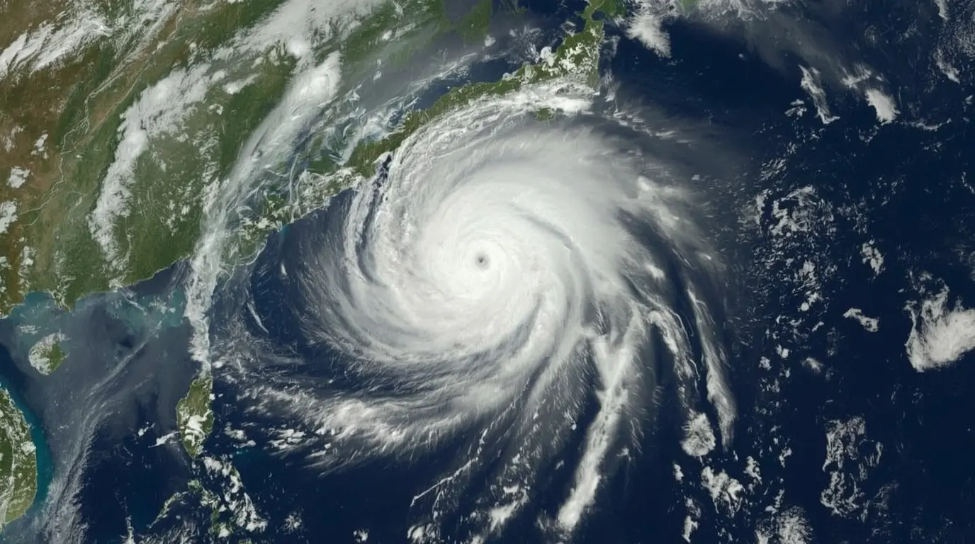
So far, Typhoon Ragasais the strongest tropical cyclone seen anywhere in the world this year, with peak sustained winds hitting a jaw-dropping 267 kph (165 mph). Although the system has eased a bit since it battered the Philippines, the wind, rain, and swelling seas it spreads are still well above average and are driving officials to strengthen safety plans across the wider Southeast Asian region. This report will keep you posted on damage reports, rescue actions, and path changes as Ragasa’s next moves unfold.
Typhoon Ragasa’s Current Status and Projected Path
As of September 23, 2025, Typhoon Ragasa is moving across the South China Sea with top sustained winds of 220 kilometers per hour (137 mph). The storm is no longer listed as “super typhoon” by the Joint Typhoon Warning Center, yet it is still equivalent to a major Category 4 hurricane by Atlantic standards. Meteorologists say Ragasa will keep a west-northwest course, putting it dangerously close to Hong Kong before it makes landfall in Guangdong Province, China, on Wednesday evening.
Forecasters believe Typhoon Ragasa will slowly weaken as it begins to enter less favorable atmosphere and, soon, contact with land. Still, the storm could remain as strong as a Category 3 hurricane as it moves just south of Hong Kong before hitting the mainland. The Hong Kong Observatory has issued warnings that hurricane-force winds may be felt offshore and along higher elevations. Heavy rains could cause storm surges and flooding in low-lying coastal areas, so residents along the expected path should prepare for serious conditions and stay tuned to official updates.
Key Metrics of Typhoon Ragasa as of September 23, 2025
| Parameter | Current Status | Peak Intensity | Projected Landfall |
|---|---|---|---|
| Sustained Winds | 220 km/h (137 mph) | 267 km/h (165 mph) | 185 km/h (115 mph) |
| Storm Classification | Category 4 Equivalent | Category 5 Equivalent | Category 3 Equivalent |
| Central Pressure | Not specified in reports | Not specified in reports | Not specified in reports |
| Projected Landfall Timing | – | – | Wednesday evening, September 24 |
Regional Impacts and Preparedness Measures
Hong Kong Braces for Direct Impact

Hong Kong is taking unprecedented precautions as Typhoon Ragasa approaches, with officials drawing comparisons to two of the most destructive storms in recent memory: Typhoon Hato (2017) and Typhoon Mangkhut (2018). Hong Kong’s number-two official Eric Chan stated unequivocally that “Ragasa will pose a serious threat to Hong Kong,” prompting comprehensive emergency measures across the special administrative region.
The government is scheduled to raise the typhoon signal to 8, the third-highest warning level, by 2:20 p.m. local time on Tuesday, which will trigger widespread shutdowns of businesses and transportation services.
The Hong Kong Observatory has just released alarming warnings about storm surges that could see coastal water levels increase by up to two meters (about six feet). In some places, the maximum surge could reach 4-5 meters (around 12-15 feet). These figures closely mimic the surges recorded during Typhoon Hato in 2017, which led to severe flooding and millions in damages. To brace for the storm, authorities are distributing sandbags in low-lying neighborhoods, and supermarkets are overflowing with shoppers grabbing essentials. Reporters from Reuters observed that milk, meat, and other staples sold out fast, with some vegetable prices at fresh markets having tripled since panic buying began. Transit across the region is already heavily affected.
Hong Kong International Airport warned that flight operations will experience “significant disruption” from 6:00 p.m. Tuesday night until 6:00 p.m. the next day. Cathay Pacific plans to cancel about 500 flights, and Hong Kong Airlines is grounding all outbound flights. The bridge that connects Hong Kong, Macau, and Zhuhai is also shutting down for safety. Meanwhile, the Hong Kong Stock Exchange has decided to remain open, having switched its rules late last year to keep trading even in severe weather.
Guangdong Province Braces for Typhoon Ragasa
Guangdong, China’s bustling province home to almost 60 million people, is bracing for Typhoon Ragasa. Local authorities have warned that conditions may turn catastrophic, prompting the provincial government to swing into action. Megacities are going into lockdown mode: schools are shutting, work is being put on hold, and buses, trains and ferries are all grounding. The scale is staggering, showing once again how exposed the region is to tropical storms and how neighbours still remember past disasters that arrived with little warning.
In Shenzhen, the province’s tech powerhouse with around 17.5 million residents, officials are getting ready for one of the biggest evacuations in the city’s history. The aim is to move 400,000 people from low-lying and coastal neighbourhoods inland. To shelter them, city managers have readied over 800 emergency centres. Guangzhou, the provincial capital and home to 18.6 million, is considering issuing its most severe red alert as the wind and rain get closer. On the mainland and in Hong Kong, residents are acting in almost the same way: supermarket cranes look like skeletal frames as shoppers sweep the aisles of bottled water, instant noodles, and batteries to prepare for days when the power and the roads may be gone.
Chinese weather authorities are ramping up flood defenses in multiple southern provinces, alerting residents that heavy rain will sweep in on Tuesday night. The National Meteorological Centre says Typhoon Ragasa, or Typhoon Nando, will hit the stretch of coast between Shenzhen and Xuwen in Guangdong on Wednesday. The whirlpool of storm that follows is likely to flood rivers and seriously damage roads and buildings .
Philippine emergency teams are now surveying the damage after Typhoon Ragasa’s first hit. The storm ranked as a super typhoon when it crossed the southern tip of the Babuyan islands, making landfall on Panuitan Island in Cagayan province on Monday, PAGASA reported. With top winds over 167 mph, it is the strongest storm recorded anywhere in the world this year. Full damage details are not available because phone and internet connections were cut, but officials say that structures, crops, and helping teams were laid low.
Sadly, the storm has already taken a life in the Philippines, where a landslide in Benguet on Luzon Island buried one person and hurt several more. The Department of the Interior and Local Government reports that more than 10,000 residents have been moved to safer areas in northern and central Luzon as a precaution. The typhoon took down electrical lines on Calayan Island and in the entire northern mountain province of Apayao, unleashing gusts that reached an astonishing 295 kph (183 mph) in spots.
Calayan Island experienced the eyewall of Typhoon Ragasa directly. Herbert Singun, the island’s information officer, spoke with the AFP about the destruction. Pieces of a school’s roof were ripped free and slammed into an evacuation center just 30 meters away, leaving one person with a minor injury. To illustrate the storm’s power, he gestured to nearby coconut trees, saying, “Eight stood there a while ago. Now only half have survived. That shows how strong this typhoon really is.”

Regional Impacts and Preparedness Measures for Typhoon Ragasa
| Region | Evacuations | Transportation Disruptions | Key Preparedness Measures |
|---|---|---|---|
| Hong Kong | Not specified | 700+ flights cancelled; Hong Kong-Zhuhai-Macau Bridge closed | Typhoon Signal 8 warning; sandbag distribution; school and business closures |
| Guangdong Province | 400,000 in Shenzhen alone | Public transportation suspended | Emergency shelters activated; schools and workplaces closed; flood controls implemented |
| Philippines | 10,000+ across northern and central Luzon | Domestic flights suspended; ferries prohibited | Government work suspended; classes canceled; evacuation centers established |
| Taiwan | 7,600+ from mountainous areas | 273 flights cancelled; rail services suspended | Forest areas and nature trails closed; heavy rain advisories issued |
Safety Recommendations and Climate Context
Essential Safety Precautions
As Typhoon Ragasa heads for busy cities, local officials are stressing safety guidelines. Following these tips can lower injuries and damage. Check trusted weather reports regularly, reinforce buildings against high winds, and evacuate if asked, especially if you live where floods from the sea can reach fast.
Emergency-management experts stress that every household should assemble an emergency kit containing key supplies like drinking water, non-perishable food, prescription medicine, flashlights, and fresh batteries. People living in evacuation zones must familiarize themselves with the safest routes to designated shelters and heed official advice about the best time to evacuate. Past typhoons, including Mangkhut and Hato, have shown that getting ready ahead of time can seriously boost public safety during these intense storms.
Climate Change Connection
Scientists have cautioned that climate change is supercharging tropical storms, turning them into systems with stronger winds and heavier rainfall. Typhoon Ragasa proves this point, clocking rapid intensification and record peak strength that match predictions of how warming ocean waters might change cyclone behavior. Studies show that while warming does not seem to boost the number of typhoons themselves, it does lift the ceiling on their peak strength and rainfall intensity, resulting in more extreme conditions when these storms arrive on land.
The presence of Typhoon Ragasa, currently the world’s most powerful storm of the year, highlights the rising worries about climate change and its effect on Pacific weather. Forecasters explain that the warm Pacific waters act like extra fuel, pushing tropical storms to stronger categories and allowing them to stay intense longer. This knowledge is crucial for planners and emergency teams who need to update readiness plans based on the new and evolving storm behavior.
Economic Impact and Conclusion
Transportation and Event Cancellations
As Typhoon Ragasa nears, travel and cargo systems across the region are feeling the strain, and the financial fallout will go well past the storm’s end. Airlines are in the hardest-hit position, with Cathay Pacific announcing the cancellation of 500 flights. Hong Kong Airlines has grounded all departures. Port closings, rail slowdowns, and canceled ferries add to the picture. Because transportation is the backbone of the economy, affected upstream and downstream operators will face delays that vanish only gradually. Estimates suggest that these disruptions may cause overall losses across sectors that could rival the HK$4.6 billion ($592 million) in damage seen from Typhoon Mangkhut in 2018.
Severe weather has already led to the cancellation or postponement of key events. Macau’s “Global Legal & Sustainable Timber Forum 2025,” set for September 23-24, will not take place as planned to protect attendees. Organizers are now finalizing follow-up logistics and will reach participants via email, SMS, and social feeds. Such decisions underscore how a single storm can ripple through the economy—empty convention halls cost hotels, restaurants, and travel companies that score no ancillary income from flights, guided tours, or social-night dinners, and the spend never arrives.
Meanwhile, the storm keeps barreling west. Trackers show Typhoon Ragasa veering toward the Southern Chinese coastline, and the peninsula is bracing for what could become this decade’s standout weather event. Radar estimates place Ragasa’s winds far wider than storm-spurge buffers, meaning that neighborhoods, roads, and entire job sectors are at risk. Still, storm chasers and agency reports already credit steady improvements since the last mega-typhoon: villages now undergo timed, leveled evacuations; sirens and tweets sound earlier; weather alerts feature neighborhood maps and fave-language buttons. Despite the threat, that exercise in institution-strength is a silver lining.
Meteorological agencies across Asia will keep a close eye on Typhoon Ragasa as its path evolves, issuing regular updates as the storm develops. Typhoon Ragasa reminds us all how exposed coastal communities can be to tropical systems, underscoring the critical need for strong disaster-preparedness plans. Scientists suggest climate change may be boosting the strength of storms like Ragasa, so the data and lessons from this event will help governments improve their future response and planning.
Source: https://edition.cnn.com/2025/09/22/asia/typhoon-ragasa-china-guangdong-hong-kong-intl-hnk
For more news updates, visit our home page.